While out boating on the beautiful waters of Lake Martin, Alabama, you have probably noticed that there are quite a few islands around – but did you know that many of these are actually popular landmarks and hangout spots too?
The islands of Lake Martin are home to some of the most fascinating stories, culture, and history in the area. Here are some fun facts and a little background on some of the most well-known islands on Lake Martin!
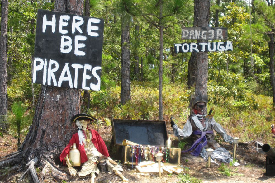
Pirate Island
Latitude 32.83305
Longitude -85.85845
Ahoy matey! Grab your crew and set sail to explore Lake Martin’s very own Pirate Island. “Guarded” by Jolly Rogers and his skeleton crew, Pirate Island is a local favorite for visitors of all ages to see.
Pirate Island was originally created over a decade ago by one family, and originally began with just a pirate flag, skeleton, and treasure chest. At the time, only one other family knew of this little secret spot, but it wasn’t long before other boaters saw the pirates and word of the island quickly began to spread. Over the years, others began to add to the décor too, and Pirate Island has become one of the most popular and unique destinations for all to enjoy on Lake Martin!
You can find Pirate Island, with all of its hand painted signs, skeletons, and Marti Gras beads, on the Tallapoosa side of the lake, near Madwin Creek.
Acapulco Rock/Chimney Rock Island
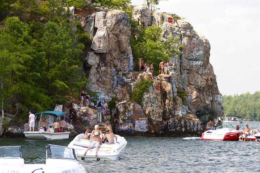
Chimney Rock is hands down one of the most iconic landmarks at Lake Martin, Alabama! Located near the Ridge Marina, it is easily recognized by the colorful artwork graffiti and the (usually) large gathering of boats around its cliffs.
To set the record straight, what everyone refers to now as Chimney Rock is actually “Acapulco Rock Island”. The real Chimney Rock is a different island just off in the distance. It can be distinguished by a large stone protruding up from the top of the island’s rocky formation, resembling very closely a chimney – hence the name. Over the years however, Acapulco Rock Island has taken over the Chimney Rock name and is now the famous hangout spot everyone so fondly refers to.
Chimney Rock is also well known for its cliff jumping. On any given summer day, you can usually find a large gathering of boats circling Chimney Rock, with people watching and cheering on daredevils as they leap off of the three main cliffs: Chicken Rock, Acapulco Rock, and Lost Boys. These three cliffs all range in height, anywhere from 20 feet high to a whopping 60 feet above the water.
It should be noted that jumping off of Chimney Rock is very dangerous and people have been seriously injured doing this. We do not in any capacity recommend or encourage people to attempt this jump.
Chimney Rock is known to be a wildly popular hangout spot in the summertime. It is a fun place to meet fellow boaters, soak in some sunshine, and enjoy the show. You can read everything you need to know about Chimney Rock here!
Sand Island

Latitude 32.76510
Longitude -85.97503
Sand Island is one of the classic islands of Lake Martin! Back in it’s prime, Sand Island was quite the popular hangout spot on the lake. It was basically a massive sandbar that people loved to beach their boats on to spend the day floating in the waters and enjoy the… well, sand.
Sadly, Sand Island today has almost entirely washed away and now all that remains are a small cluster of trees and a solo stone bench. However, it is still worthwhile to give this little island a visit – especially if you are into geocaching! This is a great place to drop by for a fun find. The cache on Sand Island is big enough for treasures to be hidden inside but also challenging enough to make it exciting for even an experienced geocacher.
This island is located in Big Kowaliga Creek, in between Kowaliga Bridge and Willow Point. If you plan to stop by this island, be prepared to jump in for a little swim! Even though the beach is long gone, it can still be too shallow in areas for boats to pull all the way up. You can watch this video on swimming to the island and finding the geocache!
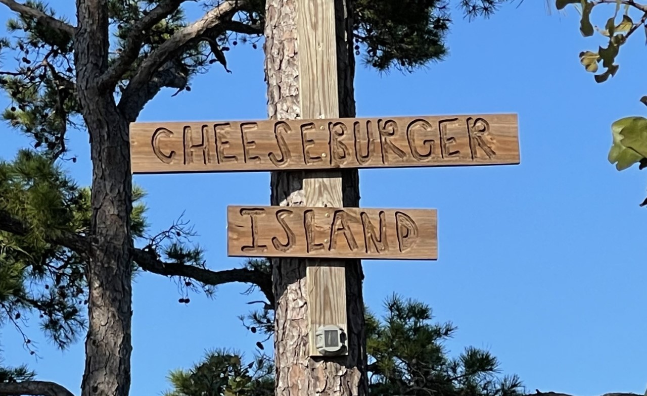
Cheeseburger Island

Latitude 32.69729
Longitude -85.91141
This popular hangout is located near the Martin Dam and can be spotted by two wooden planks reading “Cheeseburger Island” nailed up in the trees.
The island itself is not very big, but if you can find a spot to beach your boat on the small shore, it makes for a great place to float in the clear waters or hang up your hammock to catch a famous Lake Martin sunset. There is also a long wooden, table-like structure in the center of the island that many visitors use to place their drinks or food on during a long hangout day, or even lay out on to catch some sun.
There was once a treasure chest on Cheeseburger Island that had small toys for kids to enjoy during their visit. During my latest trip, the treasure chest was no longer there – however, a geocache is hidden on the island, which makes it still a fun “treasure” hunt after all.
Graveyard Island

Latitude 32.84810
Longitude -85.86254
Also known as “Cemetery Island”, Graveyard Island actually lives up to its name. This small 30 yard by 30 yard island is home to real gravesites from a town long ago, with markers dating as far back as the 1820s up to the 1920s (when the waters were flooded in to create Lake Martin). A seawall now protects the old cemetery, helping to continue to preserve its history.
This island is located in the Bay Pines area of Lake Martin, just North of Youngs Island. You can actually pull your boat up and still see the grave markers to this day.
Young’s Island

Latitude 32.82207
Longitude -85.87663
This island is another one with a very historical past. It is actually privately owned by the Young family, who were some of the earliest settlers of the area when Tallapoosa County was formed in 1832. At the time (before Lake Martin was built), ferries were a very important mode of transportation locally to cross the Tallapoosa River, and the Young family owned one of the busiest ferry operations in the county. It strategically ran from Young’s Ferry Road near D.A.R.E Park to what is now Young’s Island on the opposite side of the river.
The island itself is 55 acres and at one time actually had a homestead on it. There were also wild goats that roamed the island at one point (long before Goat Island) that were known to lounge out on the home’s big front porch. Unfortunately, it is said that in the early 1900s a fire broke out and destroyed the entire residence. What remains on the island today is the private Young family cemetery.
Peanut Point

Latitude 32.82905
Longitude -85.89551
Okay, so technically this one isn’t an island. But Peanut Point is an iconic stop along the shores of Lake Martin and definitely deserves a shout out!
Their claim to fame is having the best boiled peanuts on Lake Martin since 1988. For $5 cash, you can have your choice of classic boiled peanuts, or even spice things up with a bag of their Cajun-style snack. And don’t forget your souvenir! Just about every boater I know has a koozie or t-shirt from Peanut Point from over the years.
By boat you can find this local favorite right around the corner from Wind Creek State Park and it can easily be spotted by the pop-up tents on the shoreline.
The 4 Islands of the Island Hop Trail at Smith Mountain

This is such a fun addition to our island list! It is unique in the fact that Island Hop Trail is actually what connects a string of 4 islands, but it’s access changes with the lake seasons. Let me explain.
Island Hop Trail is a part of the CRATA (Cherokee Ridge Alpine Trail Association) hiking trail system and is located near the Smith Mountain Fire Tower.
During the winter, the water level of Lake Martin is lowered by 7 feet. It is only then, when the water level is at its lowest point, that visitors can actually walk the Island Hop Trail from island to island.
However, in the summertime when the water level rises back up, the trail is once again buried underneath the water and the islands are only accessible by a quick swim from one to another. Now that I think about it, a swim doesn’t sound too bad after a long hike around Smith Mountain!
These are just a handful of the great islands around Lake Martin! Be sure to keep on the look out for any one of these popular stops next time you hit the water.